
|
|
|||||||
| General Discussions & Announcements General Announcements, General Questions, e.g. What bike do I buy?, etc. |

 |
|
|
Thread Tools | Display Modes |
|
#1
 04-15-2014, 06:29 AM
|
|||
|
|||
|
is there a program i can use to display my trails on the pc , or a satmap users forum for help thanks british
 or is there a better gps to get? 
|

|
#2
04-15-2014, 06:54 AM
|
||||
|
||||
|
I use the runtastic app on my smart phone. Not for navigation on the trail, but for tracking where I have been. When I come home, I upload the track to runtastic.com an can see all my activities on the runtastic website. Works pretty good.
Sent fra min GT-I9505 via Tapatalk
__________________
Anders "So you know, that you're over the hill when your mind makes a promise that your body can't fill" (Little Feat: Old Folks Boogie) 2015 EC200 Racing: TE bars, Rekluse Core Exp 3.0, 38mm Lectron & Ohlins S3 steering damper 2006 EC200: 2011 plastics, Rekluse Z-Start, revalved KYB forks & Scotts steering damper 1998 Bimota Supermono 1986 Duc Mille S2 1975 Guzzi sidecar hack 1961 Morini Corsaro 125 etc
|
|
#3
04-15-2014, 11:24 AM
|
||||
|
||||
|
I've been using Garmin's MapSource program in conjunction with my 60CSx. It's a bit clunky, but works relatively well once you get used to the quirks of the program.
Here's a screen shot of what it looks like after I've pulled my track log from the GPS unit. 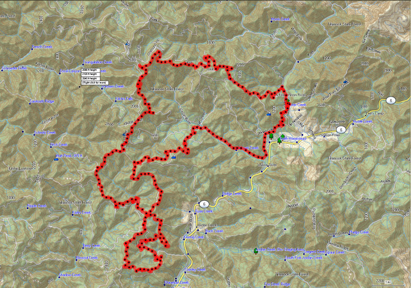 In the application, you can manipulate the track log in several ways, you can also import logs from other people and combine their tracks with your own to make a loop. That's how I started getting acquainted with various trails where I ride - asked some of the guys with experience to send me their GPS logs and then compared those to a map of the area. Good luck, even with the GPS logs, I've found myself completely lost a couple times...lol.
|
|
#4
04-17-2014, 03:00 AM
|
|||
|
|||
|
sat maps are good, or garmin 62. those are the two most people I know use, personally i have a garmin 62 and its good.
|
|

| Thread Tools | |
| Display Modes | |
|
|


 Linear Mode

